| Wrington Village Records Studies of the history of a Somerset Village The Manor and the Manor House - pages 6-8 |
|
|
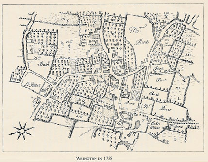
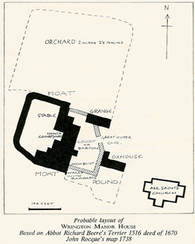
Sources: Abbot Richard Beere's Terrier of Wrington, 1516 printed in the Chronicle John of Glastonbury, ed. T. Hearne, (1726) vol. 2. Deed: Lease of Wrington Manor House, 1670 (Somerset Records Office, Ref: X/BDN). Map of Wrington Tithing, 1738, by J. Rocque. These three sources, ranging from the 16th to the 18th century, have been used together to give an overall picture of the Manor of Wrington, with special attention to the Manor House itself. From the descriptions in the terrier and the deed, and its appearance on the 1738 map, it has been possible to reconstruct ground plan of this building, once the most important and imposing house in Wrington, which hitherto has been almost completely forgotten. The Terrier is a detailed description of the Abbot of Glastonbury's property in Wrington, with special attention to his financial profits from it. The 1670 deed records a lease by which the Earl of Essex, Lord of Wrington Manor, lets "Capitall messuage and chiefe Mansion house of the Mannor" to William Porter, merchant of Bristol; and Porter assigns the lease to his future father-in-by way of a marriage settlement. The 1738 map of Wrington (for details see paper A Map of Wrington in 1738) is on a sufficiently large scale to show quite clearly the shape of the Manor House. The Terrier opens with a description of the "fair manor house". According to this, it contained "a large hall, spacious rooms on either side of the hall, storehouse, cellar, kitchen, storehouse and stable in the inner court-yard there: with high-built walls with ramparts on the eastern circumference and with deep water in the moat on the western circumference, which contains together with the lower courtyard and the garden, one acre." The deed of 1670 mentions in addition to the rooms listed above, "solars" (or withdrawing rooms), and locates the garden on the West side of the house, with a little yard or barton lying on the South side of the Stable there. The Terrier lists an outer barton with grange (or granary), and an oxhouse pound amounting to half an acre. The Western half of the grange (i.e., the nearest the manor house) was reserved for the Lord to put his hay in. The Eastern half, together with the oxhouse, was rented out to John Kene. The deed 1670 definitely places the Eastern half of the granary outside the East wall of Manor House. The Orchard containing 2 acres 2½ perches was rented by the Hayward (later identified as John Hobbes) for 3s. 4d. per year, and the deed locates this orchard on the North side of the Manor House; it also mentions a dove house, the area in the deed being the same as that given in the Terrier . Taking all the information listed above, and working on Rocque's ground plan of 1738, we arrive at the attached approximate ground plan of the manor house, bearing in mind that small additions such as a porch and some additional building at the rear had been added in the intervening 200 years. Many of the parts of the building mentioned above appear again in other papers (see Customs of the Manor, 1238, Manorial Accounts 1343-4 & 1491-2, and Manorial Court Papers, 1733-1757. What happened to this imposing building, when and why, is still something of a mystery. It was obviously still standing in 1738; but for sixty years or more - as the 1670 deed indicates -it had been let out by the absentee lord of the manor to other tenants, who themselves do not seem to have been resident. In this way it probably fell on poor days: and more or less on the same site, with "1754" clearly displayed on a scroll above the middle window of the first floor facade, we find the present Court Farm. Continuing with the terrier of 1516, beyond the great outer gate, lying on the North side of the churchyard was a "certain house. ..rented by Williall Trywebody for 4d. a year and the maintenance thereof". Williall Trywebody had previously been the tenant of Bellellylle and house. He was bailiff of Wrington in 1491-2 (see paper Manorial Accounts 1343-4 & 1491-2). The lord's sheepfold was situated at BRADFELD (undoubtedly Broadfield), and with two adjacent closes contained 9 acres; and at FERLOCKESHAY there were 6 acres 1½ perches "for sustaining the lord's sheep". The nearest field name to this is FARLIHAY, a meadow or pasture of 5¾ acres to the North side of Long Lane and 3 furlongs East of Barley Wood. LA FURLONG MEDE contained 6 acres of meadow in several (i.e. strips of meadow). This was probably pasture near the village but is unidentified. SEMSORE contained 49½ acres over which for one year from Michaelmas to Michaelmas the lord's sheep were pastured; and the second year it belonged to one Thomas Fisher. A possible identification of SEMSORE is the Sims Hill area. WULGERSHAWE contained 7½ acres of oaks, ash and underwood from which the brushwood was valued each year at 50s. LITLEBARGH and HORDACRESWODE each contained 12 acres of wood and underwood (oaks, ash and alders), which could be cut every 16 years and were then valued at 13s. 4d. an acre. Litlebargh is given as Lyttlcbarrow in the 1547 sale of the manor to Henry Capel, and Hordacrewode appears as Hurdacres. Identification of these woods is difficult, the only similarity to a modern name being Hordacrewode to Horts Wood; but both this wood and Litlebargh contained alders according to the terrier, and since the alder is a tree of the river side or swampy lands, this does not tie up with the position of Horts Wood on the well drained, south-facing hillside. It would appear, therefore, that these woods were situated in the valley, Wodefold and Wulgershaw however, would appear to have been woods of the hills, as their trees are detailed as oaks, ash and hazels. It is possible that they were situated on the south-facing slopes of Broadfield Down. The list of common woods (i.e. where the villagers also had rights) includes Kingeswode, containing 41 acres; and Colecliff, 6 acres. Here there were 2½ acres of oaks which could be lopped every 16 years, their branches then being valued by estimation at £10. Kingswood lies at the top of Broadfield Down, North West from the village of Wrington. Langrewe or Landgrewe in 1547, upon Bradfeldesdoun (Broadfield Down), contained about 20 acres in scattered areas, available for lopping every 16 years when the branches were worth about £4. In Prestover and Litleover were 20 acres of oaks and underwood in diverse little patches, which, in the same way, could be lopped in the 16th year and were then worth 4Os. These two names can be identified as the present Prestow Wood and Littler Plantation (a total area today of approximately 57½ acres). Blakemore contained 57 acres of wood and alders, from which the underwoods could be sold every 12th year, being then valued at £10. Werneshawe contained 27 acres of wood and pasture from which the loppings of the trees every 16th year was valued at 40s. Blakemore and Werneshawe appear to have been one large common, known today as Blackmoor at Langford, although the wooded nature of the country has completely changed and the area is now mainly grass land. The mention of alders in this area would have been perfectly consistent with their habitat. The largest open common was Bradefeldsdown (Broadfield Down), which contained 2,025 acres of pasture, where 400 of the lord's sheep could be pastured, as also could animals of the commoners and the lord's tenants. PRESTOVER AND LITLEOVER contained 120 acres of common but this was divided into a number of holdings. John Kenne Esq. held six acres in five pieces ; William Jones half an acre; William Forde one acre in two pieces; John Hobbes one acre (he was the Hayward) ; Isabella Ballerd one acre; Richard Horte, the customary tenant, one acre; and the Rector of the Church of Wrington one acre, separated off in alternate years for the lord's sheep. Identification of this area would appear to be in the Prestow and Littler area. A certain quarry for "petrarum liberarum" or Freestone is mentioned. The tenant is a certain John Mustard of Bradfeld. The freestone would probably be limestone and the situation, as the tenant is from Broadfield, would appear to be Broadfield Down where numerous medieval quarries existed. At Rickford was a fullers mill (fulling being a process carried out on heavy materials to cause the yarns to shrink and felt together. In the medieva] mills the cloth was stamped by water-driven hammers). This mill had been recently built by Dionisius Morowe upon ground belonging to Lady Isabella, widow of John Newton, knight. The common watercourse to this mill was held by licence by John Livell. He paid 12d. annually, at the four terms, and could transfer the watercourse to another, provided that the Lord King suffered no loss of taxes by this transfer. The churchwardens of Burrington held a piece of ground in the Lord's waste at Rushwey called Butthay, for archery targets. This contained ½ an acre and the annual rent was 2d. On another piece of land of the lord's waste in Burrington, next to Burrington churchyard, was built the Church House, on which a rent of 5d. annually was paid. This Church House was still standing in 1700, as an entry in the churchwardens' accounts for that year states "Glassing the Church House windows 2s. 3d." The exact site of the building, also used as the village's public bakery, brewery and laundry, was however, unknown when F. A. Knight referred to it in The Heart of Mendip in 1915. A memorandum states that every customary tenant "whenever he shall brew one complete brewing, shal1 give to the lord 4d. by name of Tolecestre". Tolsester was a toll on brewing, originally a measure of ale known as a sester, but by this time commuted to a cash payment. Every customary tenant was obliged also "to give for pannage for his pigs". Pannage was the payment made to the lord for the privilege of feeding beasts in the woods about the village. Customary tenants were obliged also to grind their grain at the lord's mill, customarily called Bememylle. The tenant was Edmund Leveregge, named elsewhere as a churchwarden and a furlong holder. Alternatively tenants had to pay rent annually in cash: every virgate-holder 2s. 8d. ; three-furlong-holders, 2s. ; half virgate holders 16d. ; furlong holders, 8d. ; and cottagers of old-aster tenure (old family holdings), 4d. Whoever held the mill was bound to provide the mill-stones "so that it shall not fall a burden on the lord". The appearance of Beam Mill in 1516 refutes the suggestion that it was an 18th or 19th century mill powered by a beam-engine. "La Berne" mill also appears in Customs of the Manor 1238. The mill probably took its name from the "beam" or plank bridge crossing the Yeo at this point (Beam Bridge) on the road from Wrington to Langford. Beam is a Saxon word. Edmund Leveregge also appears as a security in the paper Estreat Roll of court fines, 1528. When a death occurred a heriot (or death duty) of the best beast was pay-able to the lord. If there was no beast, virgate or half virgate holders had to provide one acre of corn. Anyone of lesser tenure, if they had so much cultivated land, had to provide half an acre of corn, stipulated as the "best". Should a wife die before her husband no heriot was owed. Should she die in the tenement after the death of her husband, and it reverted into the hands of the lord of the manor, or she died a widow, the lord would have the heriot stated above. If there was no corn, the lord was to have the best piece of goods to be found in the tenement on the day of the tenant's death. It was noted that the lord of the manor and all his tenants, both free and otherwise, had and exercised the rights of intercommoning with the lord of Blakedon (Blagdon) in his hills and moors. Likewise in the hills and moors of the Lord Bishop of Bath of his manor of Yatton, and the open hills of Mendip as far as Dunehede (Dowrihead, north east of Cranmore), and Doultyng (Doulting, near Shepton Mallet). The pasture of Mendip was not delineated. The bounds were determined, it would appear, by mutual assent between the ground of the lord of the manor and the ground of neighbours such as the Prior of the house of Carthusians at Charterhouse. MR. & MRS. H. SMITH. |
||